North Park Filing No. 8 Infrastructure SDP

This is a new development proposal! This project is currently under review and will be scheduled for hearings in accordance with the application review process timeline. This page can be utilized to stay up to date with the proposal and provide feedback on the request.
Project Overview
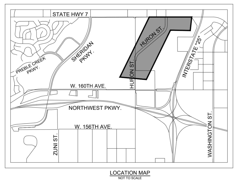
The applicant has submitted a new Site Development Plan (SDP) for the infrastructure supporting the future development of North Park Filing No. 8 and the surrounding area. This project area is generally located on the southwest corner of the I-25 interchange, and totals approximately 25 acres in size.
The Site Development Plan includes the following elements:
District Scope of Buffer Lands
Trail alignments, landscaping proposed, and initial grading concepts for the buffers along SH7, Huron Street, and I-25. These designs are in coordination and compliance with the Baseline DRC standard
Realignment of Huron Street
Design of the proposed realignment of Huron Street, along with the first phase of the roadway.
First phase of the roadway includes the First ~1,000 feet south from CO 7 will be built to the final 4 lane condition, then taper down to a 2 lane width and widened with future development.
A pedestrian underpass for the regional trail is proposed to be installed in this initial phase.
Pond 100
This SDP designs the final drainage improvements for Preble Creek and the Baseline development.
Pond 100 will be designed and developed at the far northeast corner of the site, providing drainage and storm retention for its entire basin.
Regional Trails
This SDP shows the proposed trail alignments within Baseline Metropolitan District land.
This includes the full pedestrian underpass under the realigned Huron Street, and design criteria for the pedestrian underpass beneath CO 7.
Also shown are the connections to the CO 7 trail network running east/west and connections to the Broomfield Regional Trail running north/south.
The realigned Huron Street also has two 14-foot wide micromodal trails, providing connectivity north and south along this corridor.
Project Details
Applicant: Realberry
Location: Generally located on the southwest corner of the I-25 and CO 7 interchange.
Project Type: Site Development Plan
City and County Staff Analysis
Zoning, Surrounding Uses and Comprehensive Plan:
Zoning
The property is zoned Planned Unit Development (PUD) and is governed by the North Park PUD Plan and Supplemental Binder. The proposed infrastructure and improvements are generally consistent with the approved PUD Plan and Supplemental Binder.
Surrounding Uses
The surrounding area is largely undeveloped at this time. To the north is the vacant Northlands development, which is located on the northeast corner of the CO 7 and I-25 interchange. Generally northwest of the site is the Palisade Park development, which includes the Children's Hospital, an existing gas station, and a fast food restaurant. To the south is additional vacant land within Baseline, to the southeast ia an existing burial ground/cemetery. To the east of the site is I-25, on the east side of I-25 is an existing retail center located within Thornton.
Comprehensive Plan
The property is designated as Transit Oriented Development on the 2016 Comprehensive Plan Land Use Map. The proposed infrastructure is supportive of and necessary for developing a Transit Oriented Development.
Potential Deviations:
At the time of application submittal, the applicant had not identified any deviations or special exceptions. If any elements requiring deviations or special exceptions are identified during the development review process, those deviations/special exceptions will be identified in the staff memorandums for the Land Use Review Commission and City Council.
Possible Key Issues:
Based on the initial submittal materials, staff has not identified any key issues. If any elements rising to the level of key issue are identified during the development review process, those will be identified in the staff memorandums for the Land Use Review Commission and City Council.
Public Engagement
You can engage with this project using the Questions and Comments tabs below, by emailing planning@broomfield.org or by providing comments at a public hearing. All comments provided directly via email and through the Broomfield Voice will be added to the Land Use Review Commission correspondence folder and City Council correspondence folder as applicable. This folder will be reviewed by LURC and / or City Council in advance of any public hearings on the proposal.
Following the review of the formal application, public hearings will be scheduled in accordance with the application review process timeline. Public notices will be sent to property owners within 1,000 feet of this project, sign(s) will be posted on the property and a notice will be published in the Broomfield Enterprise newspaper. Members of the public can attend the public hearings and provide in person comments if desired.