Share Miramonte Multimodal Safety Study on FacebookShare Miramonte Multimodal Safety Study on X (formerly Twitter)Share Miramonte Multimodal Safety Study on LinkedinEmail Miramonte Multimodal Safety Study link
The Miramonte Multimodal Safety Study is a comprehensive evaluation of a 2-mile stretch designed to improve safety and accessibility for people walking, biking, rolling and driving. Your input will be used to prioritize specific safety strategies and help the City and County of Broomfield (CCOB) secure grant funding for future construction.
Project Overview
This study was initiated because Miramonte Boulevard serves as a critical link between schools, parks and trails, yet faces significant safety challenges. Some segments carry higher vehicle volumes—up to 9,000 vehicles per day—others meet traffic-calming criteria due to elevated speeds or have documented crashes., This effort is underway to proactively address safety, gather neighborhood input and guide future investments in the corridor.
Project Goals
Identify Safety Concerns: Pinpoint specific risks for all modes of travel
Address Crash Patterns: Evaluate high-risk crash locations and identify countermeasures to increase safety
Improve Accessibility: Identify necessary ADA upgrades
Develop Recommendations: Identify and prioritize feasible upgrades to enhance safety and corridor functionality for all modes
Implementation Readiness: Create a prioritized list of projects for implementation and to strengthen Broomfield’s applications for outside funding opportunities
Study Area
The study covers approximately 2.2 miles of Miramonte Boulevard between 10th Avenue and Main Street. This includes the segments from Main Street to Kohl Street, Kohl Street to US 287 and the areas extending west of US 287 to Oak Circle.
The following segmentations have been identified as unique areas based on land use: (1) Main Street to Kohl Street, 0.7 mi; (2) Kohl Street to US 287, 0.4 mi; (3) US 287 to Oak Circle, 0.6 mi; (4) Oak Circle to US 287, 0.5 mi
Public Engagement
Phase One Engagement - Complete
Phase One engagement focused on understanding existing safety concerns, travel patterns and community priorities along the Miramonte corridor. The project team held three pop-up events at Broomfield High School, the Big Broomfield Playdate, and National Night Out, and organized a Walkshop along the full study corridor. The online community survey received nearly 300 responses, and more than 100 pins were added to the interactive map identifying locations of concern and opportunities for improvement. This input will help inform the development and evaluation of multimodal safety improvements.
Stay tuned for Phase Two public outreach this fall, when the community will have an opportunity to review preliminary concepts and provide additional feedback.
You can ask your questions using the “Questions” tab below. Follow the project to receive periodic updates.
The Miramonte Multimodal Safety Study is a comprehensive evaluation of a 2-mile stretch designed to improve safety and accessibility for people walking, biking, rolling and driving. Your input will be used to prioritize specific safety strategies and help the City and County of Broomfield (CCOB) secure grant funding for future construction.
Project Overview
This study was initiated because Miramonte Boulevard serves as a critical link between schools, parks and trails, yet faces significant safety challenges. Some segments carry higher vehicle volumes—up to 9,000 vehicles per day—others meet traffic-calming criteria due to elevated speeds or have documented crashes., This effort is underway to proactively address safety, gather neighborhood input and guide future investments in the corridor.
Project Goals
Identify Safety Concerns: Pinpoint specific risks for all modes of travel
Address Crash Patterns: Evaluate high-risk crash locations and identify countermeasures to increase safety
Improve Accessibility: Identify necessary ADA upgrades
Develop Recommendations: Identify and prioritize feasible upgrades to enhance safety and corridor functionality for all modes
Implementation Readiness: Create a prioritized list of projects for implementation and to strengthen Broomfield’s applications for outside funding opportunities
Study Area
The study covers approximately 2.2 miles of Miramonte Boulevard between 10th Avenue and Main Street. This includes the segments from Main Street to Kohl Street, Kohl Street to US 287 and the areas extending west of US 287 to Oak Circle.
The following segmentations have been identified as unique areas based on land use: (1) Main Street to Kohl Street, 0.7 mi; (2) Kohl Street to US 287, 0.4 mi; (3) US 287 to Oak Circle, 0.6 mi; (4) Oak Circle to US 287, 0.5 mi
Public Engagement
Phase One Engagement - Complete
Phase One engagement focused on understanding existing safety concerns, travel patterns and community priorities along the Miramonte corridor. The project team held three pop-up events at Broomfield High School, the Big Broomfield Playdate, and National Night Out, and organized a Walkshop along the full study corridor. The online community survey received nearly 300 responses, and more than 100 pins were added to the interactive map identifying locations of concern and opportunities for improvement. This input will help inform the development and evaluation of multimodal safety improvements.
Stay tuned for Phase Two public outreach this fall, when the community will have an opportunity to review preliminary concepts and provide additional feedback.
You can ask your questions using the “Questions” tab below. Follow the project to receive periodic updates.
Help identify safety concerns and shape future improvements—take the survey today and be entered to win a $100 dollar gift card!
Be sure to complete the interactive mapping activity as well.
Share Miramonte Safety Survey on FacebookShare Miramonte Safety Survey on X (formerly Twitter)Share Miramonte Safety Survey on LinkedinEmail Miramonte Safety Survey link
Page last updated: 20 Aug 2026, 06:40 PM
Stay informed
Subscribe for project updates
Data Collection
Miramonte Multimodal Safety Study has finished this stage
Spring 2026
Summer Outreach and Engagement
Miramonte Multimodal Safety Study has finished this stage
Summer 2026
Alternative Analysis and Concept Design
Miramonte Multimodal Safety Study is currently at this stage
Summer - Fall 2026
Fall Outreach and Engagement
this is an upcoming stage for Miramonte Multimodal Safety Study
Fall 2026
Study Completion and Final Report
this is an upcoming stage for Miramonte Multimodal Safety Study


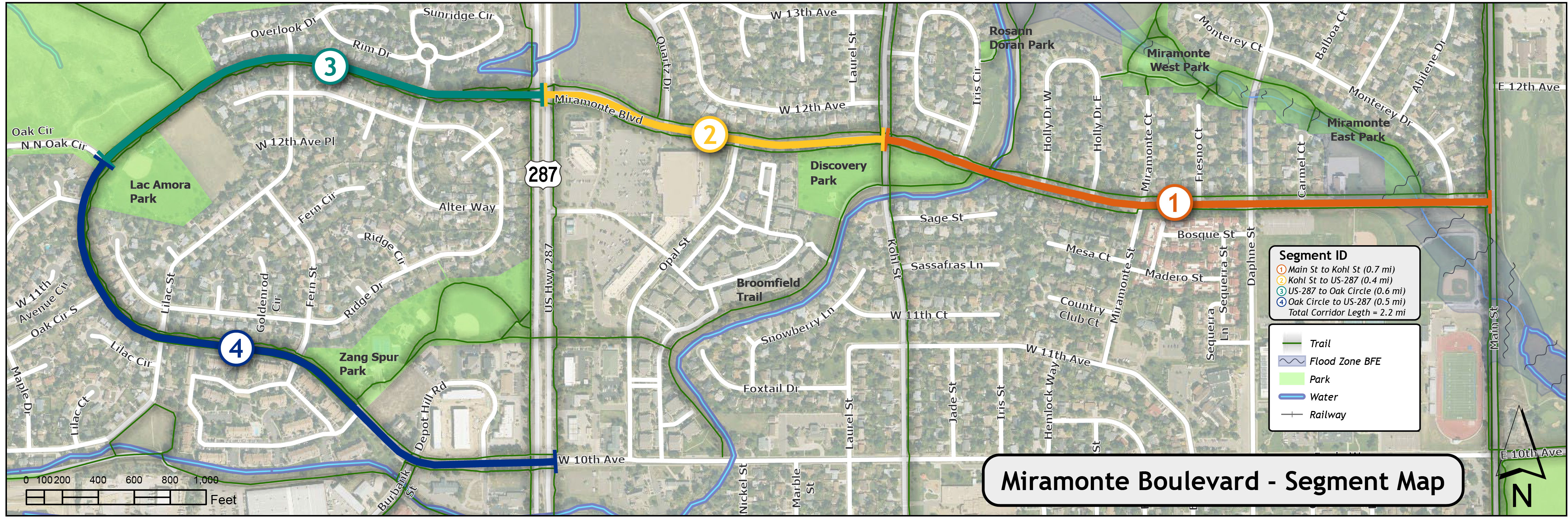 The following segmentations have been identified as unique areas based on land use: (1) Main Street to Kohl Street, 0.7 mi; (2) Kohl Street to US 287, 0.4 mi; (3) US 287 to Oak Circle, 0.6 mi; (4) Oak Circle to US 287, 0.5 mi


