Share Flood District Outreach Project on FacebookShare Flood District Outreach Project on X (formerly Twitter)Share Flood District Outreach Project on LinkedinEmail Flood District Outreach Project link
City Park Channel is part of a mapped floodplain regulated by the Federal Emergency Management Agency (FEMA). A Conditional Letter of Map Revision (CLOMR) will be developed and submitted to FEMA before construction starts on the project. The CLOMR was submitted in early Summer 2023 and approved in March 2025. A final Letter of Map Revision (LOMR) will be prepared and submitted to FEMA after Phase 2 is constructed. When approved, the LOMR will result in the remapping of the City Park Channel floodplain and floodway from US 287 to just downstream of Main Street.
Project Overview
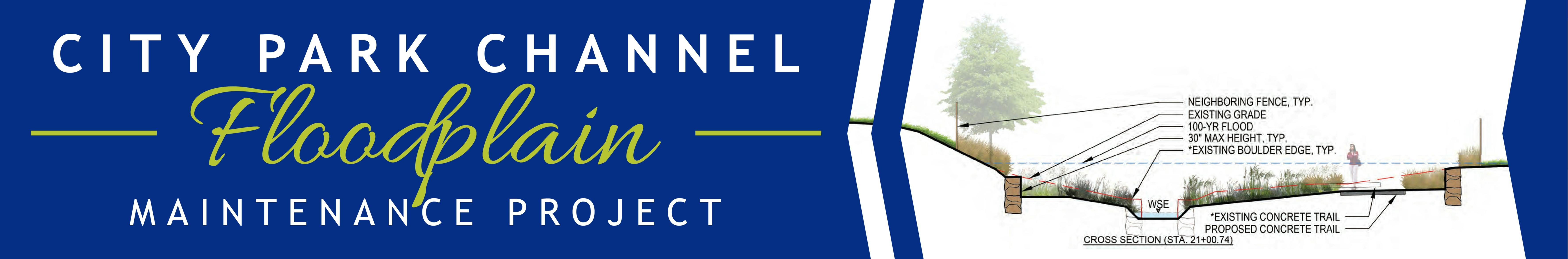
The conceptual plans for the Channel between US 287 and Main Street cover a large area. To complete the improvements, the project will need to be phased as capital improvement funds are allocated. A Phase 1 project was identified to progress to final design and construction. Phase 1 improvements will extend approximately 300 feet to the East and West of Main Street along City Park Channel. Improvements will center around an enlarged concrete box culvert under the roadway for the channel and will add a pedestrian crossing under Main Street. The enlarged crossing for the drainageway will allow the 1% annual chance storm event (100-year storm) to be conveyed completely under the roadway and will no longer overtop Main Street. To accommodate the pedestrian undercrossing, the invert of the channel will be lowered by approximately 4 feet, and the roadway will be raised by approximately 1.5 feet in the immediate vicinity of the drainageway. To accommodate the channel lowering, a sculpted concrete drop structure will be added to the drainageway to the west of Main Street. To accommodate the improvements, the existing irrigation culvert for the Harry Brown Ditch will be reconfigured. Multimodal improvements will include the pedestrian undercrossing that will meet ADA criteria and the reconstruction of the bike lanes on Main Street. The existing at-grade pedestrian crosswalk with a signalized light will be replaced with a High-intensity Activated Crosswalk (HAWK) pedestrian crossing beacon.
In the Spring of 2022, conceptual construction drawings were completed for the City Park Channel between US 287 and Main Street. A Phase 1 project was identified from the conceptual design to progress to preliminary and final construction plans. With coordination for the Broomfield Town Square development, Phase 1 was revised to include the channel upstream and downstream of Main Street and the pedestrian underpass at Main St. Preliminary construction plans were completed in 2024 and will continue to final construction plans by late Summer 2025. Additional field data collection was completed before the development of the preliminary plans including expanded limits for Survey and Subsurface Utility Engineering (SUE), which is necessary for the design to be complete. Early utility relocation is underway as of Spring 2025. Geotechnical information was also gathered to analyze the soils in the area to inform structural and pavement designs. Staff will continue to coordinate with the Mile High Flood District (MHFD), and internal stakeholders, including Parks & Recreation, Public Works, and Transportation as well as with the Broomfield Town Square development
The Mile High Flood District held a public information meeting on April 13, 2022.
City Park Channel is part of a mapped floodplain regulated by the Federal Emergency Management Agency (FEMA). A Conditional Letter of Map Revision (CLOMR) will be developed and submitted to FEMA before construction starts on the project. The CLOMR was submitted in early Summer 2023 and approved in March 2025. A final Letter of Map Revision (LOMR) will be prepared and submitted to FEMA after Phase 2 is constructed. When approved, the LOMR will result in the remapping of the City Park Channel floodplain and floodway from US 287 to just downstream of Main Street.
Project Overview
The conceptual plans for the Channel between US 287 and Main Street cover a large area. To complete the improvements, the project will need to be phased as capital improvement funds are allocated. A Phase 1 project was identified to progress to final design and construction. Phase 1 improvements will extend approximately 300 feet to the East and West of Main Street along City Park Channel. Improvements will center around an enlarged concrete box culvert under the roadway for the channel and will add a pedestrian crossing under Main Street. The enlarged crossing for the drainageway will allow the 1% annual chance storm event (100-year storm) to be conveyed completely under the roadway and will no longer overtop Main Street. To accommodate the pedestrian undercrossing, the invert of the channel will be lowered by approximately 4 feet, and the roadway will be raised by approximately 1.5 feet in the immediate vicinity of the drainageway. To accommodate the channel lowering, a sculpted concrete drop structure will be added to the drainageway to the west of Main Street. To accommodate the improvements, the existing irrigation culvert for the Harry Brown Ditch will be reconfigured. Multimodal improvements will include the pedestrian undercrossing that will meet ADA criteria and the reconstruction of the bike lanes on Main Street. The existing at-grade pedestrian crosswalk with a signalized light will be replaced with a High-intensity Activated Crosswalk (HAWK) pedestrian crossing beacon.
In the Spring of 2022, conceptual construction drawings were completed for the City Park Channel between US 287 and Main Street. A Phase 1 project was identified from the conceptual design to progress to preliminary and final construction plans. With coordination for the Broomfield Town Square development, Phase 1 was revised to include the channel upstream and downstream of Main Street and the pedestrian underpass at Main St. Preliminary construction plans were completed in 2024 and will continue to final construction plans by late Summer 2025. Additional field data collection was completed before the development of the preliminary plans including expanded limits for Survey and Subsurface Utility Engineering (SUE), which is necessary for the design to be complete. Early utility relocation is underway as of Spring 2025. Geotechnical information was also gathered to analyze the soils in the area to inform structural and pavement designs. Staff will continue to coordinate with the Mile High Flood District (MHFD), and internal stakeholders, including Parks & Recreation, Public Works, and Transportation as well as with the Broomfield Town Square development
The Mile High Flood District held a public information meeting on April 13, 2022.
Share News & Updates on FacebookShare News & Updates on X (formerly Twitter)Share News & Updates on LinkedinEmail News & Updates link
Expectations during construction: For work in the parks, portions of the use area will be closed adjacent to the creek. For work on Agate and roadway crossings, detours may be in place. Access to residence homes will be maintained throughout.
Expectations during construction: For work in the parks, portions of the use area will be closed adjacent to the creek. For work on Agate and roadway crossings, detours may be in place. Access to residence homes will be maintained throughout.
Share What Does This Mean? on FacebookShare What Does This Mean? on X (formerly Twitter)Share What Does This Mean? on LinkedinEmail What Does This Mean? link
Federal Emergency Management Agency (FEMA) - FEMA is Headquartered in Washington, D.C., and has 10 regional offices located across the country. FEMA leverages a tremendous capacity to coordinate within the federal government to make sure America is equipped to prepare for and respond to disasters.
Flood Insurance Rate Maps (FIRM) - FEMA produces Flood Insurance Rate Maps (FIRM) and Flood Hazard Boundary Maps (FHBM). The FIRM is the most common map used by communities. At a minimum, flood maps show flood risk zones and their boundaries, and may also show floodways and Base Flood Elevations (BFE). More recent flood map products include digital FIRMs (DFIRM). Communities may incorporate DFIRMs into their Geographic Information System (GIS) databases.
Flood Zone AE Designation - "100-year" regulations/insurance requirements apply. We will provide plans and floodplain workmaps when they finalized and available.
Floodway - A "Regulatory Floodway" means the channel of a river or other watercourse and the adjacent land areas that must be reserved in order to discharge the base flood without cumulatively increasing the water surface elevation more than a designated height.
Special Flood Hazard Area (SFHA) - A SFHA is an area identified by the United States Federal Emergency Management Agency (FEMA) as an area with a special flood or mudflow, and/or flood related erosion hazard, as shown on a flood hazard boundary map or flood insurance rate map.
Conditional Letter of Map Revision (CLOMR) – A CLOMR is a letter from FEMA's stating a proposed project that would, upon construction, affect the hydrologic or hydraulic characteristics of a flooding source and thus result in the modification of the existing regulatory floodway, the effective BFE or SFHA.
Letter of Map Revision (LOMR) - A LOMR is the Federal Emergency Management Agency's (FEMA's) official modification to an effective Flood Insurance Rate Map (FIRM). LOMRs can result in a physical change to the existing regulatory floodway, the effective Base Flood Elevations (BFEs), or the Special Flood Hazard Area (SFHA).
Page last updated: 09 Apr 2025, 10:43 AM
Next Steps
Conceptual Design - Spring 2022
Flood District Outreach Project has finished this stage
Muller Engineering developed conceptual design plans for the drainage way between US 287 and Main Street.
Phase 1 Construction Project Identified - Summer 2022
Flood District Outreach Project has finished this stage
Broomfield staff identified limits of a Phase 1 capital improvement project for City Park Drainage way.
Field Data Collection for Phase 1 final design - Winter 2022-2023
Flood District Outreach Project has finished this stage
Expanded data needed to finalize design for Survey, Subsurface Utility Engineering (SUE), and Geotechnical Data.
Conditional Map revision submitted to FEMA - Summer 2023
Flood District Outreach Project has finished this stage
Conditional approval of the improvements to the drainage way is required by FEMA prior to the start of construction work.
Preliminary Construction Plans for Phase 1 Construction Project - Early 2024
Flood District Outreach Project has finished this stage
Phase 1 includes an enlarged culvert for City Park Drainageway under Main Street and features the addition of a pedestrian undercrossing with a scupted concrete drop structure to lower the elevation of the channel under the roadway.
Anticipated approval of Conditional Map revision by FEMA - March 2025
Flood District Outreach Project has finished this stage
Early Utility Relocation - Spring 2025
Flood District Outreach Project is currently at this stage
Final Construction plans for Phase 1 Construction Project - 2025
this is an upcoming stage for Flood District Outreach Project
Muller Engineering will complete final design and issue construction plans for Phase 1 improvements.
Construction of Phase 1 project - TBD
this is an upcoming stage for Flood District Outreach Project
Construction will begin on the enlarged culvert and drop structure, pedestrian under crossing, local roadway improvements, and associated work to complete the Phase 1 Construction Project.