
What Does This Mean?
Federal Emergency Management Agency (FEMA) - FEMA is Headquartered in Washington, D.C., and has 10 regional offices located across the country. FEMA leverages a tremendous capacity to coordinate within the federal government to make sure America is equipped to prepare for and respond to disasters.
Flood Insurance Rate Maps (FIRM) - FEMA produces Flood Insurance Rate Maps (FIRM) and Flood Hazard Boundary Maps (FHBM). The FIRM is the most common map used by communities. At a minimum, flood maps show flood risk zones and their boundaries, and may also show floodways and Base Flood Elevations (BFE). More recent flood map products include digital FIRMs (DFIRM). Communities may incorporate DFIRMs into their Geographic Information System (GIS) databases.
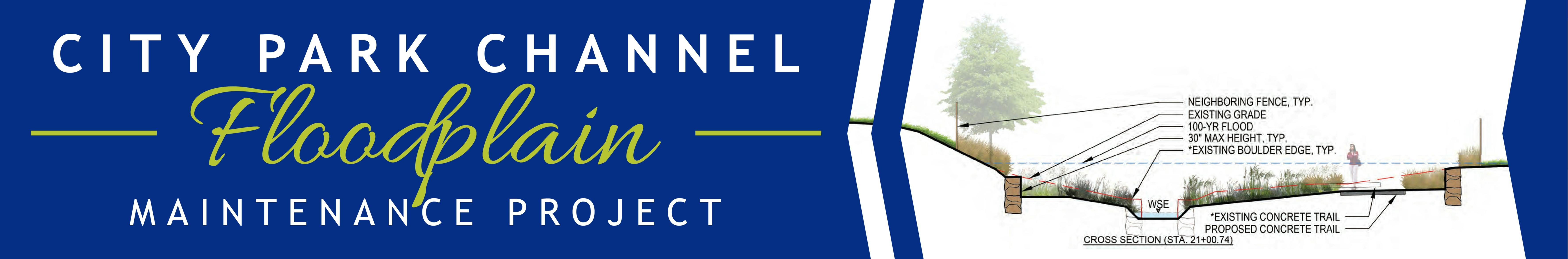
Flood Zone AE Designation - "100-year" regulations/insurance requirements apply. We will provide plans and floodplain workmaps when they finalized and available.
Floodway - A "Regulatory Floodway" means the channel of a river or other watercourse and the adjacent land areas that must be reserved in order to discharge the base flood without cumulatively increasing the water surface elevation more than a designated height.
Special Flood Hazard Area (SFHA) - A SFHA is an area identified by the United States Federal Emergency Management Agency (FEMA) as an area with a special flood or mudflow, and/or flood related erosion hazard, as shown on a flood hazard boundary map or flood insurance rate map.
Conditional Letter of Map Revision (CLOMR) – A CLOMR is a letter from FEMA's stating a proposed project that would, upon construction, affect the hydrologic or hydraulic characteristics of a flooding source and thus result in the modification of the existing regulatory floodway, the effective BFE or SFHA.
Letter of Map Revision (LOMR) - A LOMR is the Federal Emergency Management Agency's (FEMA's) official modification to an effective Flood Insurance Rate Map (FIRM). LOMRs can result in a physical change to the existing regulatory floodway, the effective Base Flood Elevations (BFEs), or the Special Flood Hazard Area (SFHA).
