The Shop - Flex Use Space 4101 Industrial Lane
ARCHIVED
The applicant withdrew the application after one referral agency and Planning staff review.
THIS IS A FORMAL DEVELOPMENT REVIEW APPLICATION FOR AN INDUSTRIAL FLEX BUILDING - Planned Unit Development Plan, Final Plat (replat), and Site Development Plan/Urban Renewal Site Plan
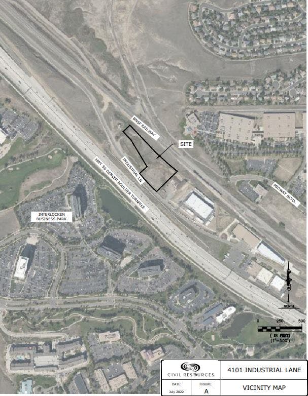
Location: Northeast side of US Highway 36, east of the E Flatiron Crossing Drive and Midway Boulevard intersection
Project Type: Development Review Application for a PUD, Final Plat (replat), and Urban Renewal Site Plan/Site Development Plan
Project Description: The proposed development is a proposal to improve a 3-acre lot with three buildings to be used for limited industrial-related flexible spaces. Each building will house individual units ranging in size between 1,000 - 1,250 square feet. Each unit will have two access doors - an overhead garage door and an entry door. The spaces will each have rough plumbing and be conditioned with heating and cooling. Landscaping, lighting, and parking are also proposed.
The proposal also includes dedicating additional right of way along Industrial Lane to provide for the planned bicycle trail improvements along this road.
The PUD identifies the potential uses. Per the Urban Renewal Plan, self-service storage facilities are only permitted within multistory structures designed to emulate multifamily or office buildings with access only from the interior of the building. No unit doors may face the street or be visible from off the property. Parking is shown to be screened from views along the US 36 Highway Corridor.
Property Owner/Applicant: E & J Rocky Mountain/4101 Industrial LLC and/or Assigns
APPLICABLE CITY AND COUNTY OF BROOMFIELD PLANS
Conformance with the Zoning and Compatibility with Surrounding Uses: The property is zoned Planned Unit Development (PUD), but requires a PUD Plan. It is also subject to the US 36 West Corridor Urban Renewal Plan and the Interchange Influence Area. Design guidelines require that the buildings are oriented towards the highway and that parking is screened and setback.
The adjacent uses include an office/warehouse immediately to the southeast. To the northwest, there is a Colorado Department of Transportation (CDOT)-owned 1.61-acre lot with a detention pond and a Broomfield-owned lot that is used for a lift station that serves Interlocken.
The proposed uses appear to be compatible with the surrounding uses. Further review of the preliminary list of uses will continue throughout the review process.
The Comprehensive Plan designation for the property is "Industrial", which are areas characterized by light and heavy industrial, office, manufacturing, research and development, warehousing, and some commercial uses.
Per the US 36 West Corridor Urban Renewal Plan Design Standards:
Set back parking spaces located along Industrial Lane and include landscape buffering. Parking is located interior to the site, with the 3 buildings oriented along the exterior lot lines.
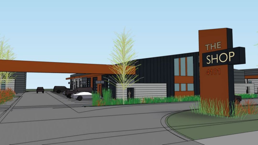
Orient buildings towards the front of the lot, which in this case is US Highway 36. The site plan shows the building's front elevation oriented towards US Highway 36 with landscaping along the frontage. The buildings include glazing along the frontage with fenestration through vertical finishes.
Create a pedestrian-friendly image along the street frontages. This can include windows for the front-facing buildings and other architectural features. This property fronts a planned route for a regional bike path. A regional trail segment is shown to run parallel to US Highway 36 and Industrial Lane. Sidewalks into and throughout the site are shown on the site plan.
Design the on-site detention pond to resemble a natural water body; this could include keeping the existing contours of the site. The design of the detention pond will be carefully reviewed during this formal development review process.
Access, Parking, Landscaping, and Setbacks: One point of access is proposed from Industrial Lane with two entrance gates. Drive aisles provide circulation into and throughout the site. Parking spaces are interspersed throughout the site being immediately in front of the 3 buildings, with ADA-accessible spaces placed at the northwest of the site. EV parking is proposed.
Landscaping in the form of trees, ornamental grasses, and shrubs is shown around the perimeter of the site. Landscaping is especially concentrated along the front street edge of the lot.
Setbacks are established as follows: Front - 20 feet, sides - 15 feet, and rear - 40 feet. The site plan shows dimensioned setbacks for the parking and buildings within those setbacks.
Water and Utilities There is an active well on the property. At the time of building permit issuance, it will be required for the building to be tied into the water and sewer lines that are in close proximity to the subject site. Continued use of the well would require approval by the city council. Utility, drainage, and geotechnical reports have been submitted with this formal development review application and is currently under review.
Drainage and Detention The detention pond is shown at the northwest portion of the site. Further review of the detention pond to ensure that it meets the intent of the design criteria of the urban renewal plan will take place during this formal development review. The detention pond must be designed per the Mile High Flood District guidelines.
Signage A monument sign is proposed at the entrance to the site; this will be reviewed to ensure it meets the sign code requirements.
Relationship to Comprehensive Plan: The Broomfield Comprehensive Plan designation for the site is “Industrial”, which allows for the proposed limited industrial flexible uses. These proposed uses are in compliance with the Comprehensive Plan.
Goals and Policies - The proposed project would help meet the following Comprehensive Plan goal:
- Goal LU-F: Encourage and support a variety of industrial land use types and intensities in designated areas that are both supported by and compatible with surrounding land uses.
- LU-F.1: Encourage and support the development of industry in locations that minimize the overall impact.
- LU-F.5: Support a variety of scales of business employers, from small local businesses to corporate office and headquarters.
Key Issues: Staff has not identified key issues with this proposed development.
Next Steps: The applicant withdrew the application after one referral agency and Planning staff review.
Development Review Submittal Package (First Submittal)
-
 Project Narrative-3-10-23.pdf (132 KB) (pdf)
-
Final Plat exhibit (2.74 MB) (pdf)
-
Planned Unit Development Plan exhibit 3-10-23.pdf (1.66 MB) (pdf)
-
Urban Renewal Site Plan Exhibit.pdf (16.2 MB) (pdf)
-
4101 Industrial Lane-Color Exterior Views-3-13-23 (1).pdf (2.56 MB) (pdf)
-
Utilty Report - 02-24-23.pdf (3.09 MB) (pdf)
-
Natural Resources Report.pdf (2.68 MB) (pdf)
-
Geotechnical Report draft.pdf (2.68 MB) (pdf)

Who's Listening
-
Planning Division

Phone 303-438-6389 Email planning@broomfield.org