

North Park Filing No. 7 Replat A SDP and Final Plat
ARCHIVED
This project was approved by City Council on March 24, 2026.
Project Summary
McWhinney (the applicant) submitted an application for a Final Plat and Site Development Plan related to the Center Street District in the North Park (Baseline) development. This was the initial commercial phase of a multi-phased mixed-use development. This project was approved by City Council on March 24, 2026.
This development application included two components:
North Park Filing No. 7 Replat A Final Plat
This final plat replats the North Park Filing No. 7 Final Plat super blocks created into private lots for vertical development and tracts for District improvements.
North Park Filing No. 7 Replat A Site Development Plan
The application also includes a Site Development Plan for the same area impacted by the final plat. The Site Development Plan provides the design for the architecture, streetscape, parking and landscaping for the first phase of the Center Street District development.
Project Details
Applicant: McWhinney
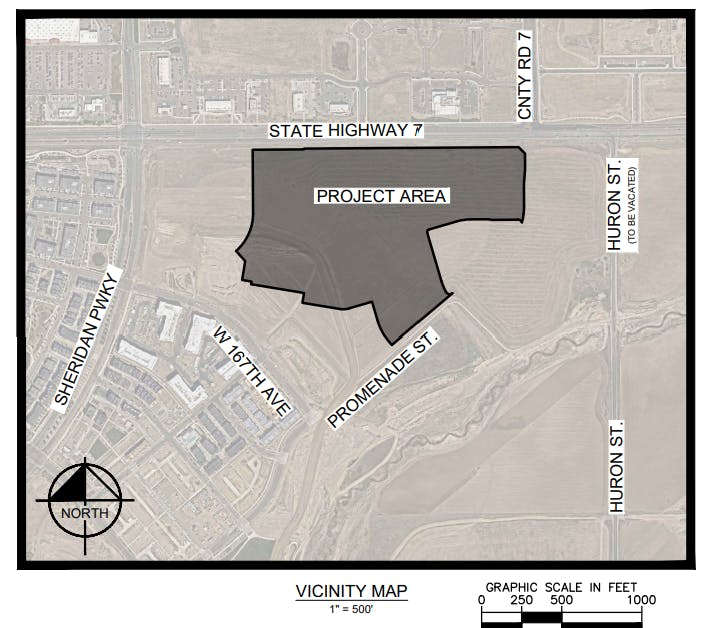
Location: Generally east of Sheridan Parkway, south of CO 7
Project Type: Final Plat and Site Development Plan related to Center Street District including architecture and landscaping.
Development Composition and Land Uses
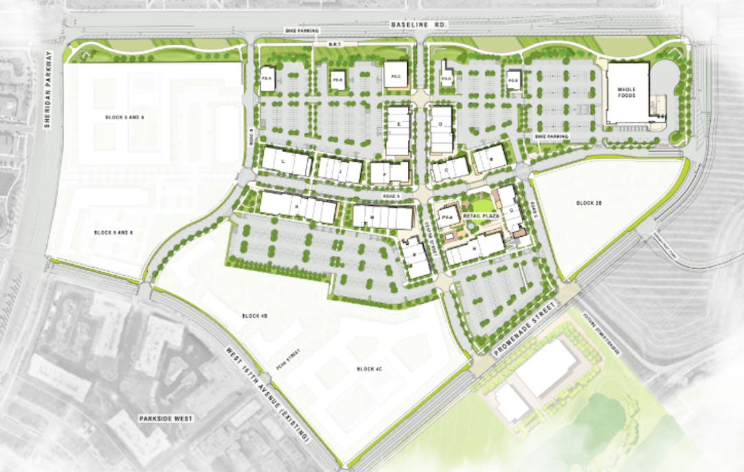
The development proposes to develop approximately 315,000 square feet of non-residential uses. These will include a mixture of retail, restaurants and drinking establishments, offices, and other similar commercial type uses. Specific tenants are not identified at this time by the applicant; however, they do note that the district will have an anchor grocer included in the development. The grocer's site is proposed on the northeast corner of the Center Street District.
Architectural Concept
The applicant describes the architectural vision for the Center Street District as being grounded in a philosophy of refined simplicity and warm, tactile expression. Drawing from the guiding pillars of “A Backdrop for Life,” “Living Green,” “Effortlessly Eclectic,” and “Artful Expression,” the buildings emphasize clean, sustainable forms crafted from an authentic palette of materials, including warm stone materials, natural wood-grain aluminum siding, textured masonry, and dark bronze metal accents. These elements come together to create a unified yet richly textured streetscape that supports a variety of tenants and uses.
The applicant also notes that the scale and rhythm of the façades are thoughtfully modulated through parapet heights, recessed entries, storefront glazing, and tower elements, creating a dynamic but approachable pedestrian experience. Storefronts are grounded by robust materials like stone veneer and CMU block in warm, earth-toned hues, offering both durability and a human-scale charm that invites interaction and discovery.
Urban Design Concept
The applicant describe the urban design for the Center Street District as being crafted to create a vibrant, walkable destination with a strong sense of place and architectural identity. The plan establishes a highly connected block structure defined by active frontages, a multi-modal street network, and a layered public realm. At the heart of the district lies the intersection of two roads that are intentionally framed by a three-story office building that anchors the southwest corner. This prominent structure provides a bold vertical element that greets visitors with an immediate sense of urban scale and density, setting the tone for a dynamic and contemporary main street experience.
On the east side of the project, the retail plaza is carefully framed by another three-story mixed-use building that rises above the open space to provide a strong architectural backdrop. This structure’s height and programmatic flexibility support both retail activity and upper-floor office uses, giving the plaza an inviting, human-scaled enclosure while maintaining a sense of vertical presence. Together, these bookending forms create visual landmarks that guide movement and reinforce a legible civic core.
Building heights across the district range from single-story boutique retail with traditional gabled roof forms mixed with contemporary simple forms, strategically framing paseos to preserve light, comfort, and pedestrian scale. The urban fabric is further activated through wide sidewalks, planted parkways, and a network of public open spaces, paseos, and trail corridors that link into the broader Baseline system.
Parking and Parking Strategies
The Center Street District is designed to function as a walkable, mixed-use destination that balances vehicular accessibility with a strong commitment to urban design and sustainable mobility. To support this vision, the project employs a shared parking strategy that aligns with the district’s diverse land uses and dynamic activity patterns throughout the day and week. Rather than applying static, one-size-fits-all parking ratios to each individual building or use, the project team commissioned a comprehensive shared parking study to assess real world demand across office, retail, food and beverage, and grocery functions.
The intent of the shared parking analysis is to better reflect the efficiencies that arise in a compact, pedestrian-oriented environment, where different uses peak at different times and many trips are internally captured, such as a customer dining after visiting the grocery store, or an office worker stopping by a retail store without moving their car. This approach supports a more sustainable, space-efficient parking supply by leveraging complementary demand patterns, reducing unnecessary pavement, and reinforcing walkability.
Importantly, while shared parking allows for overall efficiency and flexibility across the district, it is recognized that certain retail tenants, particularly grocers and national retailers, require dedicated parking ratios as a condition of lease agreements. These user specific needs are respected and planned for within the development, ensuring that market expectations are met and commercial viability is maintained. Within this framework, the shared parking model still allows the broader district to optimize its land use, consolidate parking resources, and support a vibrant public realm without overbuilding parking.
As the Center Street district evolves, the shared parking model also provides capacity to adapt. Future development phases may incorporate additional uses like education or residential, which can benefit from existing underutilized parking at off-peak times. Parking management tools and Transportation Demand Management (TDM) strategies - including transit incentives, carpool support, and enhanced bike amenities - will further reduce parking pressure and align with the district’s long-term mobility goals
Parking is positioned behind buildings support walkability, and maintain continuous active edges. The result is a thoughtfully layered, people-focused district where building massing, landscape, and movement patterns work together to foster an engaging, inclusive, and enduring urban environment. The applicant is proposing less parking than is required per code/PUD requirements and this is due to their desire to employ a shared parking model. The applicant is also including electric vehicle parking as part of their development proposal in compliance with Broomfield electric vehicle charging requirements.
Landscaping Design Concept
The applicant describes the landscape vision for Center Street as being rooted in ecological sensitivity, placemaking, and a deep commitment to the principles of the Baseline Pollinator District. The design integrates a layered, performance-driven approach that marries functional infrastructure with native beauty and biodiversity. A robust and regionally appropriate plant palette, guided by the Baseline Approved Planting List (BAPL), emphasizes native species, drought-tolerant grasses, and perennials selected specifically for their ability to support pollinators such as bees, butterflies, and birds.
Key planting zones include the Retail Corridor Pollinator Mix, Native Seed Mix, and Ornamental Grass Mix, each contributing seasonality, texture, and ecological habitat throughout the district.
The streetscape planting strategy employs generous rows of deciduous street trees and understory beds to define pedestrian zones and buffer vehicular activity, while simultaneously providing shade, comfort, and urban canopy continuity. Sidewalks are framed by enhanced paving and planted edges that shift between ornamental grasses, native shrubs, and vibrant wildflowers to create a varied pedestrian experience.
Crucially, stormwater conscious design is interwoven throughout, with wet meadow seed mixes deployed in low-lying swales and buffers along Highway 7 and Sheridan Parkway, which the applicant believes promotes not only infiltration but also seasonal drama.
The public realm is punctuated by a series of plaza zones, overlook decks, and furnishing nodes; including benches, fire pits, bike racks, and planters; that invite pause, social gathering, and outdoor dining. Retail frontages feature step-out zones with pollinator-friendly plantings directly adjacent to patios and storefronts, creating a seamless integration between landscape and architecture.
Parking lots are softened by high-canopy shade trees and perimeter plantings, using tree understory mixes and buffer landscaping to maintain visual quality and microclimate regulation.
The applicant notes that the overall landscape framework celebrates the Baseline ethos: high-performing green infrastructure, immersive public space, and vibrant, pollinator-rich ecology that turns the district into a model for resilient, place-based urban design.
Proposed Phasing
The Center Street District is planned to be developed in two major phases, with a strategically robust first phase designed to establish a strong commercial foundation and attract regional interest. This initial phase encompasses the core of the retail main street, including a substantial concentration of food and beverage, grocery, and service retail uses along the internal roads. By delivering a critical mass of active ground-floor tenants and public realm improvements, including plazas, wide pedestrian zones, and trail connections, Phase 1 is poised to create an immediate sense of place and catalyze the site as a regional destination.
The second phase, located on the western edge of the district, is envisioned as a high-density mixed-use extension that may include multifamily residential, office, and additional retail. This future phase will build upon the vibrancy established by Phase 1, enhancing the district’s urban character and supporting long-term growth with a diverse and compact neighborhood form. Phase 2 is anticipated to occur in future years with market demand and would be required to go through separate land development applications.
Proposed Special Exceptions and Variances
The applicant is proposing 2 special exceptions/variances as part of their Site Development Plan.
- Request to reduce the required setback for on-site monument signs along CO7 from 20 feet to 0 feet. This would still maintain a 15 foot separation from the CO-7 right-of-way.
- Reduction in parking by 116 spaces compared to code and PUD requirement. The applicant is proposing to utilize shared parking to reduce the number of spaces on site to minimize impervious area.
Process
While Final Plats are typically reviewed by the Land Use Review Commission and subject to the City Council call up provision - because the final plat is associated with a Site Development Plan that exceeds 7 acres in size, both the Final Plat and Site Development Plan would follow the traditional process and require public hearings by both Land Use Review Commission and City Council. This would require a public hearing with both boards with the Land Use Review Commission making a recommendation and City Council making a final approval or denial decision,
Key Issues
No key issues have been identified by staff as part of this application at this time. The applicant's proposed variances do not raise any major concerns as they are not anticipated to result in any detrimental impact to the development. If any key issues are identified through the review process they will be added to this website and shared with the Land Use Review Commission and/or City Council.
Public Engagement Summary
Members of the public provided feedback through the BroomfieldVoice and direct communication to City Council. Those public comments were part of the agenda packet and were available for the Council's review prior to approval of the project.
Project Location
Documents
-
 6th Referral
-
5th Referral
-
4th Referral
-
3rd Referral
-
2nd Referral
-
1st Referral
-
 North Park Filing No. 7 Replat A - Project Description - 1st Referral (445 KB) (pdf)
-
North Park Filing No. 7 Replat A - Final Plat - 1st Referral (1.99 MB) (pdf)
-
North Park Filing No. 7 Replat A - Site Development Plan - 1st Referral (186 MB) (pdf)
-
North Park Filing No. 7 Replat A - Color Plan Set - 1st Referral (26.5 MB) (pdf)
-
North Park Filing No. 7 Replat A - Shared Parking Study - 1st Referral (1.78 MB) (pdf)
-


Who's Listening
-
Planning Division

Phone 303-438-6284 Email planning@broomfield.org