Baseline: Parklands South Open Lands and Trails Amenity (Southern Phase)
Share Baseline: Parklands South Open Lands and Trails Amenity (Southern Phase) on FacebookShare Baseline: Parklands South Open Lands and Trails Amenity (Southern Phase) on X (formerly Twitter)Share Baseline: Parklands South Open Lands and Trails Amenity (Southern Phase) on LinkedinEmail Baseline: Parklands South Open Lands and Trails Amenity (Southern Phase) link
ARCHIVED
This proposal was approved by City Council on August 8, 2023.
Application Status:
Approved by City Council on August 8, 2023. Construction is expected to begin during the summer of 2024.
Location:
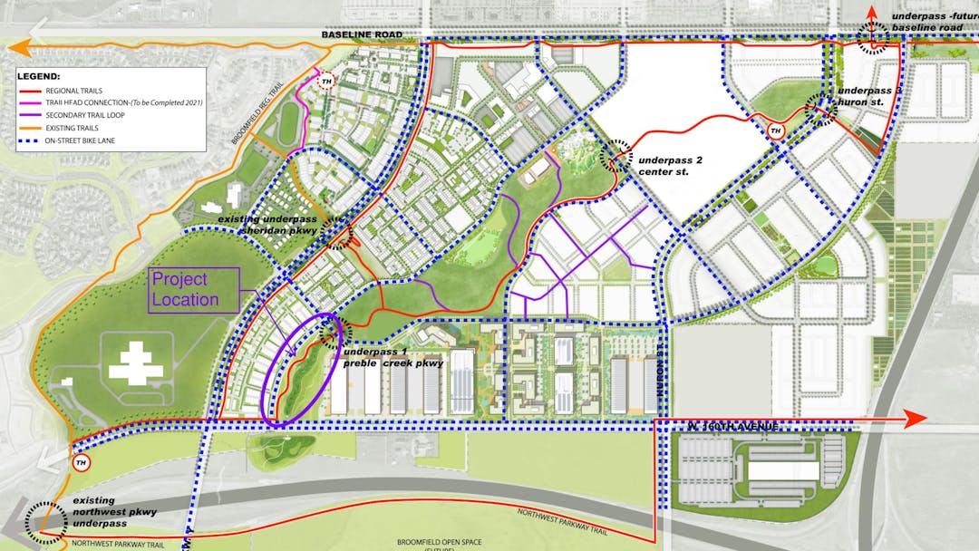
The subject proposal is located within the Baseline development northeast of Sheridan Parkway and W. 160th Avenue. The location is highlighted with a purple oval on the adjacent map.
Project Type:
Open Lands and Trails Amenity
Project Description:
The subject proposal is for a phase of the open lands and trails amenities within the Baseline master-planned community. The proposal encompasses an approximately 12-acre property designed for the stormwater management and recreational needs of the community. The plans depict:
grading improvements along the Preble Creek drainageway;
landscaping improvements including street trees along the west perimeter (street trees along the south will be done with the adjacent roadway improvements), cottonwood trees along the drainageway, and native seed to stabilize the slopes; and
a new 12-foot concrete regional trail with a 3-foot crusher fines path running parallel to the concrete trail. This southern segment of the regional trail will extend from W. 160th Avenue on the south to the future location of Preble Creek Parkway to the north. The future parkway will bisect the open lands and the future trail extension will pass below the parkway. In the near term, the regional trail will tie in with a second 10-foot wide trail extending along the east side of future Promenade Street to create a looped trail amenity.
The extension of the open lands and regional trail amenity will be phased over time and will eventually extend to the northeast to Colorado Highway 7. A public park is planned in a separate phase to the north. The open lands and trail amenities will be accessible to the public.
Note: North is to the right in the image above.
To view the full submittal please refer to the document library in the upper right corner.
Applicant:
McWhinney
Conformance with the Zoning and Compatibility with Surrounding Uses:
The subject proposal is consistent with the overall master plan for the Baseline development. Staff has not identified any key issues with this application.
Long Range Financial Plan: The application is consistent with Broomfield's land use assumptions and there is no anticipated impact on Broomfield's Long Range Financial Plan.
Application Status:
Approved by City Council on August 8, 2023. Construction is expected to begin during the summer of 2024.
Location:
The subject proposal is located within the Baseline development northeast of Sheridan Parkway and W. 160th Avenue. The location is highlighted with a purple oval on the adjacent map.
Project Type:
Open Lands and Trails Amenity
Project Description:
The subject proposal is for a phase of the open lands and trails amenities within the Baseline master-planned community. The proposal encompasses an approximately 12-acre property designed for the stormwater management and recreational needs of the community. The plans depict:
grading improvements along the Preble Creek drainageway;
landscaping improvements including street trees along the west perimeter (street trees along the south will be done with the adjacent roadway improvements), cottonwood trees along the drainageway, and native seed to stabilize the slopes; and
a new 12-foot concrete regional trail with a 3-foot crusher fines path running parallel to the concrete trail. This southern segment of the regional trail will extend from W. 160th Avenue on the south to the future location of Preble Creek Parkway to the north. The future parkway will bisect the open lands and the future trail extension will pass below the parkway. In the near term, the regional trail will tie in with a second 10-foot wide trail extending along the east side of future Promenade Street to create a looped trail amenity.
The extension of the open lands and regional trail amenity will be phased over time and will eventually extend to the northeast to Colorado Highway 7. A public park is planned in a separate phase to the north. The open lands and trail amenities will be accessible to the public.
Note: North is to the right in the image above.
To view the full submittal please refer to the document library in the upper right corner.
Applicant:
McWhinney
Conformance with the Zoning and Compatibility with Surrounding Uses:
The subject proposal is consistent with the overall master plan for the Baseline development. Staff has not identified any key issues with this application.
Long Range Financial Plan: The application is consistent with Broomfield's land use assumptions and there is no anticipated impact on Broomfield's Long Range Financial Plan.
Thank you for your interest in this development application that has been submitted to the City and County of Broomfield.
You can submit public comment for this project by clicking the link below.
If you would prefer to provide your written comments directly to the case planner, please send an email to the individual identified under "who's listening".
ARCHIVED
This proposal was approved by City Council on August 8, 2023.