Baseline Center Street District Concept Review
ARCHIVED
This concept review was concluded on June 21, 2022. The applicant did not submit a formal development application following the concept review, but should the applicant move forward this page will be reactivated and updated.
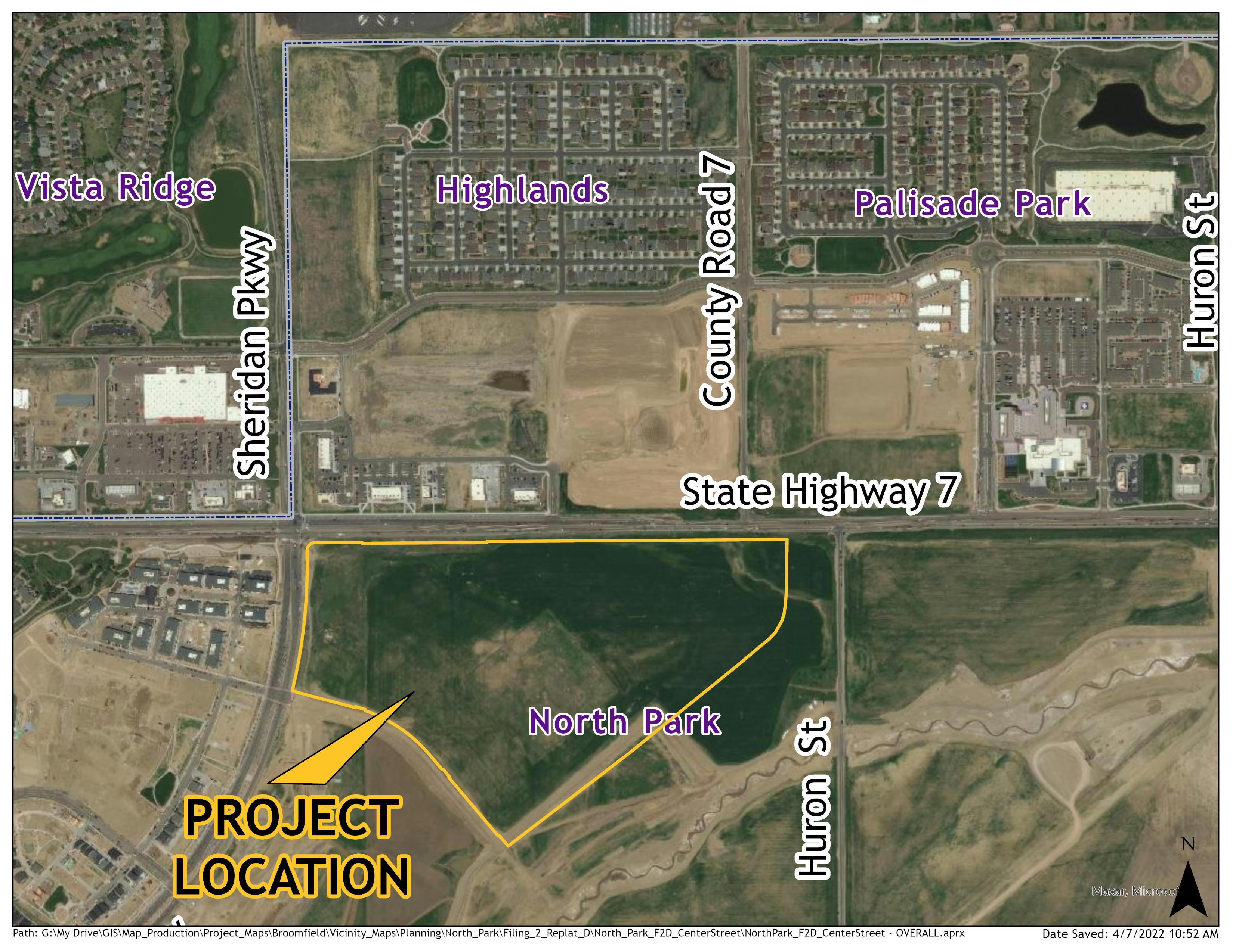
Location: Generally located on the southeast corner of the intersection of Sheridan Parkway and CO 7
Project Type: Concept Review for Mixed Use Development
Applicant: McWhinney
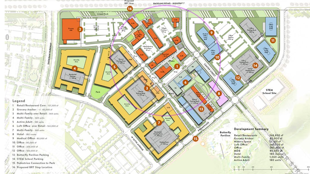
Project Description: McWhinney has submitted a conceptual plan for a proposed new mixed use district within the Baseline development. The proposed new district is being branded as the “Center Street District” and consists of approximately 63 acres on the southeast corner of the Sheridan Parkway and CO 7 intersection. The Center Street District is proposed to consist of approximately 215,000 square feet of commercial/retail (including an anchor grocer), 620,000 square feet of office (including traditional office, loft office, and medical office), a 180 room hotel, and 1,240 residential units (including 180 active adult units).
The applicant’s conceptual plans provide preliminary site design including building and parking locations, proposed amenities areas, and access points onto the site. Should the development move forward greater levels of details will be incorporated into a formal site development plan.
To view the full submittal please download the concept review packet within the document library.
Consistency with Zoning and Comprehensive Plan: The project area is zoned Planned Unit Development (PUD), and governed by the North Park PUD Plan. The North Park PUD Plan was originally approved by City Council on October 13, 2009. The North Park PUD totals approximately 1,106 acres, and is intended to develop as a mixed-use development. North Park is also commonly referred to as Baseline, and is generally located between the Community Ditch and I-25, and south of CO-7 and north of W 160th Avenue.
Permitted uses within the North Park PUD include office, services, retail, multi-family, and single-family residential uses. In addition to the North Park PUD Plan, there is a Supplemental Binder which establishes the detailed design requirements and development standards for the master planned development.
This project is located within the Mixed Use Urban District (MUD) established in the North Park PUD Plan, the supplemental binder further divides the MUD into three subcategories: Urban Core, General District, and Perimeter District. This project is located in the Urban Core subcategory area. The North Park PUD Supplemental Binder defines the MUD as a compact dense walkable community, which is intended to consist of a variety of land uses mixed both horizontally and vertically. The MUD is intended to be organized around discernible centers which are the Urban Cores. These Urban Cores are intended to encourage more use of vertically mixed buildings, higher intensities, and variety of uses, and to provide highly amenitized pedestrian gathering spaces. The overall goals of the MUD are to create an urban framework to attractively and vibrantly integrate commercial, employment, and residential uses; focus on the pedestrian experience; serve as the urban core or “heart” for the largely suburban surrounding North Metro Denver region; and to create desirable amenities for attracting primary employers.
The MUD allows for office, retail/commercial, medical and hotel uses to have maximum building heights of 160 feet. The district allows multi-family residential in single use buildings to be up to 140 feet tall and multi-family residential in mixed use structures to be up to 160 feet tall. The intent is for ground floors of buildings within the MUD Urban Cores to be occupied by active uses that engage the street scale. The proposed development is consistent with the allowed uses in the North Park PUD Plan.
The underlying comprehensive plan land use designation is Mixed Use Commercial. The proposed development is consistent with the development patterns anticipated in areas designed mixed use commercial on the comprehensive plan.
Public Land Dedication: The North Park PUD Plan establishes a minimum of 145.01 acres of PLD based on the current total number of units permitted throughout the entire PUD area. Based on the approved PUD Plan, the 145.01 acres needs to meet the following minimum standards:
- Publicly Dedicated Land
- The North Park PUD Plan will include a minimum of 109.46 acres of open lands dedicated to the City and County of Broomfield.
- The North Park PUD Plan will include a minimum of 109.46 acres of open lands dedicated to the City and County of Broomfield.
- Private Land with Public Access
- A minimum of 19.31 acres of open land will be privately owned by Metro Districts, Owners Associations or similar ownership, but will have a public access easement as approved by Broomfield.
- A minimum of 19.31 acres of open land will be privately owned by Metro Districts, Owners Associations or similar ownership, but will have a public access easement as approved by Broomfield.
- Private Land without Public Access
- A minimum of 16.24 acres of private Open Lands that are privately owned by Metro Districts, Owners’ Associations, or similar ownership. These areas need to be usable open lands and minimum standards are established in the North Park PUD.
- A minimum of 16.24 acres of private Open Lands that are privately owned by Metro Districts, Owners’ Associations, or similar ownership. These areas need to be usable open lands and minimum standards are established in the North Park PUD.
The North Park PUD provides the overall public land requirements but does not specify the obligation required per project. Each project is evaluated on its own merits and contributes toward meeting the overall public land obligations for North Park. The amended MGDA establishes triggers and thresholds for PLD obligations and improvements and as those triggers are met improvements will be completed.
The neighborhood is within walking distance of a number of privately owned neighborhood parks and the future linear park corridor along the Preble Creek drainageway (generally to the east / southeast of the project area). All of these open areas tie into Broomfield’s regional trail network via the Sheridan Parkway underpass which will be extended as part of the development of the previously approved Southlands and East Village projects to the south.
McWhinney is currently working on the design for the next phase of the Linear Park and Preble Creek drainageway improvements. Construction drawings for the drainageway improvements are being reviewed by Broomfield’s Engineering division, and the site development plan for the portion of the linear park from Preble Creek Parkway south to W 160th Avenue is anticipated later this summer.
Inclusionary Housing Obligation: McWhinney negotiated an alternative agreement to satisfy the overall North Park inclusionary housing obligation as part of their amended MGDA. It was determined that based on the current residential entitlements for the overall North Park development (8,405 dwelling units), that a total of 1,059 affordable dwelling units would be required by buildout. The applicant has not identified any specific inclusionary housing elements as part of this conceptual site plan. Should the development move forward, the applicant will be required to provide an overview of this development proposal and how it is complying with the approved alternative agreement for the development.

Who's Listening
-
Planning Division

Phone 303-438-6284 Email planning@broomfield.org